HuntaZeitung. — The US Army is studying two methods to improve communications between its helicopter fleet and soldiers on the ground.
The Small Airborne Networking Radio (SANR) program would instantaneously transmit ground soldier location information to maps in cockpits overhead to minimize fratricide. Soldiers would be able to transmit target coordinates quickly for better air support, whereas today, a pilot will listen to coordinates and write them on a leg pad.
"We've got to get out of that, that's old technology we have now and we have to be smarter," said Maj. Gen. Daniel Hughes, program executive officer for command, control, communications-tactical (PEO C3T). "What we do now has to make sense financially and technically."
The program is expected to draw offerings from more than a half-dozen radio manufacturers, some displayed at the Association of the US Army's convention here this week. Among them, Rockwell Collins showcased its TruNet, and Harris Corp. its Harris Airborne Multi-Channel Radio.
As envisioned, SANR would be a two-channel, software-defined radio that could carry voice and data via Soldier Radio Waveform (SRW), Wideband Networking Waveform (WNW) and the legacy Single Channel Ground and Airborne Radio System (SINCGARS), which transmits voice but not data.
The Army is expected to issue an RFP in 2016 followed by source selection, flight tests and airborne integration and qualification, with a possible award in 2019, according to an industry source. It could take as long as 10 years to field all 7,000 aircraft.
SANR, which is funded in the president's proposed budget, will proceed in 2016. But the service is in the process of deciding on how to move ahead on its requirement for another data link for helicopters, Link 16.
Link 16 is a military tactical data exchange network used by the US and NATO nations. It supports the secure exchange of text messages and imagery, data, and provides two channels of digital voice.
The Army has already fielded an airborne radio that carries Link 16. Through a sole-source procurement in 2013, the Army selected a two-channel radio co-developed by ViaSat and Harris, the small tactical terminal, (STT) for the UH-60 Apache helicopter.
The Army launched a Small Airborne Link 16 Terminal (SALT) program, though an anticipated request for proposals for SALT was put on hold while the Army determines whether it needs SALT in addition to SANR. A decision about how to proceed should be made soon.
"Getting Link 16 into that aircraft is absolutely critical," Hughes said. "Whether we have Link 16 and SRW, the Army is looking at the requirement to make sure we have it right and we have a plan to go forward."
"You have SANR to all the helicopters and SALT to just the Apaches and you have solutions out there to give them the Link 16 capabilities," said Col. James Ross, project manager for tactical radios. "It's a matter of whether we go to the SALT program for that or another means the aviation community will be able to do."
The Army has been developing the SRW over the last few years, but has yet to field it in a wide variety of products or fulfill plans to deploy it across the Army, amid fluctuations in Army networking programs. At the same time, the Army has in recent years demonstrated in its Network Integration Evaluation exercises the use of its Rifleman Radio, which uses SRW, in helicopters.
As the Army proceeds with SANR, the players from the crowded radio market are expected to include BAE, Exelis, General Dynamics, Harris, Northrop Grumman, Rockwell Collins and Thales.
Rockwell Collins launched software-defined ground and airborne radios at the convention under the label TruNet. Rockwell, known for its airborne radio, the ARC-210/Talon, would offer a variant for SANR, company officials said.
Bob Esselborn, the company's account manager for ground tactical radios, said the company's edge is its expertise in porting software-defined radios, like the ARC-210. "Our engineers have been doing this for 10, 15 years and that allows us to be competitive," he said.
Ray Cerrato, Harris' senior manager for business development, showed off its prototype Harris Airborne Multi-Channel Radio at the convention, touting the company's experience with WNW, as the contractor for SRW and as the manufacturer of the Falcon III AN/PRC-152, which supports SINCGARS.
"We're ready to go, we're ready to compete, and Harris is very strong in the waveform arena," Cerrato said.
Earlier I was on Youtube checking out videos that people all over the World filmed with remote controlled Drones and I was blown away. I bet if you are a photographer by now you may have already pondered the thought of catching some brilliant shots with these. Below I posted some videos that I thought were so good that they should be shared. The quality of some of these background shots with location are simply magnificent. A lot of Industries like Photography and Real Estate can really benefit from this technology and I can only expect more and more professionally shot Drone videos to be produced as time goes by.
At the 1:20 mark of this video the Drone flies over a Volcano! Being able to film shots like that while dodging chunks of lava flying at an expensive camera is what made this spectacular footage.
Below are some awesome shots from around the World. At the 1:50 mark they catch a great night time view of the City.
At the 30 second mark of this compilation of videos you will view one of the best shots I have ever seen so far. I might be wrong but I bet that part was filmed some where in Central Florida.
Why now
We want to empower makers anywhere to create apps that fit their purposes. Imagine an agriculture app that surveys your land; a search & rescue app; a football practice app. Before DroneKit, if you wanted to create any of these single-purpose apps for a drone you’d have to reinvent the wheel, building all the flight control software from the ground up. DroneKit abstracts away the hard parts of writing flight control software, leaving you a clean, modern interface to code on.
A good analogy is the smartphone: In order to make a smartphone app, you don’t need to design and create a phone first. The hard part (the platform, in other words) is already done. With DroneKit, we’ve made the phone, so to speak. Now everyone has the creative freedom to build apps and new functions.
“Unlike other APIs for drones, there are no levels of access to DroneKit; it’s completely flexible and open,” noted Brandon Basso, 3DR’s VP of Software Engineering. “The platform works on laptops as well as mobile devices. Best of all, once an app is created, the app automatically works on any computing platform—the interface is always the same.”
Our role is to maintain DroneKit: we created the API; we’ll fix any issues with it; we assure it works with all APM vehicles; we add experimental features from our labs and from those contributed by the global community, and we make all updates available to anyone for free. And should you develop an app, just put it up on 3DR Services, “the app store for drones,” where you can price it how you want, and we won’t take anything off the top. DroneKit is a community garden for technology; we want anyone to be able to use it to cultivate and take their product to market.
What you can do with DroneKit:
With DroneKit, you can develop apps for three platforms: mobile apps (DroneKit Android); web-based apps (DroneKit Cloud); and onboard computer apps (DroneKit Python) [i.e., for a companion computer on the actual drone].
DroneKit allows you to:
Fly paths with waypoints
Fly in spline path with fine grain control over vehicle velocity and position
Have the drone follow a GPS target
Control the camera and gimbal with regions of interest points
Access full telemetry from the drone over 3DR Radio, Bluetooth, Wi-Fi, or over the internet
View playbacks and log analysis of any mission
Advantages of DroneKit:
Truly open; no “levels” of access that you get from other proprietary programs
Computer agnostic: Create an app for controlling drones on whatever computing platform you want, and the interface is always the same
Works on planes, copters and rovers
Works on laptop computers as well as mobile devices
Provides web-based access to vehicle data
DroneKit powers the most successful flight control programs in the world:
Tower (formerly Droidplanner), hands-down the best flight planning mobile app out there, was built on DroneKit for Android
Droneshare, the global social network for drone pilots, is built on DroneKit web services
Project Tango Indoor Navigation is built on Pixhawk, APM and Tower
IMSI/Design TurboSite aerial reporting app for construction
Online Access
To find out how to write your own application for UAVs, and to walk through some example apps from us, please visit dronekit.io
Facebook is building a fleet of V-shaped unmanned aerial vehicles (UAVs), also known as drones, to help the company with its Internet.org project that aims to beam Internet access to the 5 billion people that don't have it yet.
According to а report from The New York Times,, Facebook has a codename for its drone: Aquila, which is also the name of the eagle in Greek mythology that carries Zeus's thunderbolts for him.
Aquila can reportedly stay in the air for up to three months at a time, and beam high-speed internet from between 60,000 and 90,000 feet in the air. They'll be lighter than a small car, but as long as a Boeing 767.
The first flights will reportedly begin this summer, although "commercial deployment may take years," the Times notes. Facebook executives are not sure how much the final version of Aquila will cost the company.
Aquila was accomplished via Facebook's acquisition of the drone maker Ascentain 2014, according to the Times. But now that this project is under Facebook's wing, the company is also looking for partners to help get the project off the ground, in return for allowing those companies to use their data and technology.
The Internet.org initiative, which was created in August 2013, is one of the main ways Facebook looks to spread its influence. By partnering up with mobile companies like Samsung, Qualcomm, and Microsoft, Facebook hopes to eventually offer universal affordable internet access, similar to Google's Project Loon, where high flying balloons beam down WiFi to areas without internet.
Drones are more than just flying robots designed for commercial deliveries and buying Crocs. Despite some lingering suspicion from consumers, unmanned aircrafts have been deployed for social good too. They can aid rescue missions, navigate tough regions and even put out fires. Now, Austin-based ArchAerial's new drone mission could potentially save lives in war-torn regions that are prone to accidents and fatalities from unexploded bombs.
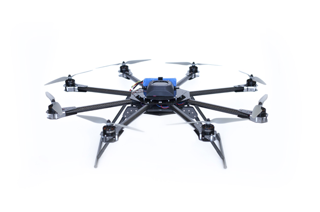
An aerial imaging firm, ArchAerial, already employs multi-rotor aircrafts for agricultural mapping, academic research and archeological surveys. Over the weekend at SXSW, Ryan Baker, the company's CEO, announced that his firm plans to deploy a prototype that will help map battlefield bunkers and aid strategies to locate unexploded bombs in areas historically ravaged by war. The humanitarian drone, essentially an Octocopter, will be loaded with LiDAR, a remote sensing technology that 3D maps the surface of the Earth with immaculate precision. If the mission goes as planned, it will keep surveyors from setting foot on the ground without any knowledge of the explosive landscape.
ArchAerial's first mission will be in Laos, a country quite literally scarred from the Vietnam War. The US dropped about two million tons of explosives within a span of nine years, making Laos, a small Southeast Asian country the most bombed area in the world. Half a century later, an estimated 80 million baseball-sized bombs scattered across the country continue to threaten civilian lives.
Для просмотра панорамного видео может быть использован Samsung Gear VR или Oculus Rift
Во время прошедшей в Сан-Франциско конференции для разработчиков F8 Developer Conference глава Facebook Марк Цукерберг представил «телепортационную станцию». Она демонстрирует возможности виртуальной реальности, с которой начинает работать социальная сеть.
Как сообщает Mashable, в ближайшем будущем соцсети, по словам Цукерберга, будут поддерживать сферическое видео. Ролики с обзором 360 градусов будут транслироваться прямо в новостной ленте. Для просмотра такого видео может быть использован Samsung Gear VR или шлем виртуальной реальности Oculus Rift, компанию-разработчика которого год назад приобрел Facebook.
Напомним, двумя неделями ранее о начале поддержки 360-градусного видео заявили в YouTube. Пока просмотр панорамного видео возможен только в браузере Google Chrome, а также с помощью специального Android-приложения на смартфонах. В список экшн-камер, видео с которых будет поддерживаться сервисом, вошли такие аппараты как Bublcam, Giroptic’s 360cam, IC Real Tech’s Allie, Kodak’s SP360 и Ricoh Theta.
The Federal Aviation Administration is still scrambling to decide how to regulate drones in American airspace, but there's at least one thing we know for sure: You're not supposed to use drones to make money.Well, even that isn't as clear as we thought.
This week, Motherboard says, the FAA sent a scary letter to drone lover Jason Hanes, telling him to stop posting his drone videos to his website or he'd be subject to fines. The reason: Those videos are on YouTube, and YouTube has ads, therefore he's using drones to make money.
It's a strange case. Clearly the FAA rules are targeted at business that would use UAVs for a specific commercial purpose, such as Amazon's proposed fleet of delivery drones, or drones that would carry banner ads behind them as they fly over a crowded beach. Hanes would appear to fall into the hobbyist category that the FAA has mostly left alone (as long as those hobbyists keep their aircraft away from football stadia, bridges, and the White House).
Yet his case could have repercussions for all kinds of hobbyist drone pilots who like to share their videos, many of which you've seen right here at PM. Says Motherboard:
Where, exactly, does commercial use begin and hobby use end, for instance? If you fly for fun, but happen to sell your footage later, were you flying for a "commercial purpose?" What if you give it to a news organization that runs it on a television station that has ads on it? What if you upload it to YouTube and Google happens to put an ad on it? What if you decide to put an ad on it?
Legally, it looks like FAA just opened a big ol' can of drones.
Руководство сети ресторанов в Сингапуре не особенно доверяет представителям вида Homo sapiens. Поэтому заявило о том, что вместо людей в их точках общепита будут работать дроны!
Жужжащие аппараты компании смогут быстро разносить заказы по залам, не будут плевать в еду и скандалить из-за чаевых.
Вес каждого дрона — около двух килограммов. При этом он способен нести на себе пару бокалов пива или вина или не слишком массивные закуски. Чтобы летающие официанты не врезались в посетителей, все они оснащены инфракрасными датчиками. Впрочем, как ты понимаешь, техника может выйти из строя, так что ждем новостей в стиле «Неисправный официант отрезал туристу голову винтом».
Sharing a private aircraft with 6-7 other people can be a quick way to get from A-B and a way of generating new business at the same time, by networking in the sky. A number of new Business Jet companies have embraced today’s new disruptive technologies and bringing private jet travel to a whole new group of people.
JetSmarter
Launched in March 2013, JetSmarter is essentially a cross between a tech company, travel agent, and airline – and aims to bring private jet travel to the masses.
With already 200,000 active users it is well on track to achieve that.
For booking private charter flights, the process is simple…
JetSmarter is an App and, just like booking a regular flight, enter your departure and arrival cities, plus the date and time of travel.
With 3,200 private jets in its fleet, available at any time, JetSmarter and its independent partners display the schedules and locations of the jets through the App. Users can request flights from anywhere in the world, and as close as six hours before departure.
Plus, just as Uber allows you to choose what car you want – be it a regular sedan, limo, or larger vehicle – JetSmarter offers flyers the same flexibility, depending on their needs. Users can see photos of the planes, plus the interior layout and amenities on board.
JetSmarter doesn’t actually own these planes; they belong to its charter firm partners – who are also responsible for maintenance, inspections, and pilots. JetSmarter is essentially the middle man that facilitates the travel part.
So for all of JetSmarter’s comparisons to Uber, there’s a big difference between a company that generates roughly $30 million per year from three to four bookings per day, and the multi-billion-dollar valuation behind Uber – a company that makes $30 million per week from roughly one million rides.
JetSmarter’s founder and CEO, Sergey Petrossov wants to make it the “Uber of the sky,” and knows that prices need to be driven down to meet this goal.
JetSmarter draws inspiration from another disruptive tech company – eBay . It functions like an online auction site.
For example, let’s say a husband and wife charter a JetSmarter private jet from Logan Airport in Boston to Nantucket Island for a quick getaway. But for their trip home, the couple won’t need the jet.
Nevertheless, JetSmarter’s plane will still need to leave Nantucket, whether the couple is on board or not. So the company will send push notifications to JetSmarter members in the Nantucket area who need a flight, and let them bid for it at a steep discount. That’s much better than the plane leaving Nantucket empty, and gives JetSmarter revenue it otherwise wouldn’t have made.
There’s another way that JetSmarter is going after ordinary folks…
Got No Friends? Share a Jet.
All the planes in JetSmarter’s private fleet come with multiple seats – around seven or eight. So that $4,000 flight from New York to Dulles is a lot more affordable if it’s split between a group of friends, or business colleagues traveling together.
But what about people flying solo?
Petrossov has them covered through the next leg of its business – “jet sharing.”
Let’s say John and Jane charter a private jet from New York to Los Angeles for $6,000. However, the jet they’re flying on has eight seats, leaving six available.
With jet sharing, John and Jane can sell those seats to someone else – in this case, $750 each.
I just pulled up tickets for a United Airlines economy flight from JFK to LAX, and got the following rates…
Lowest Fare (Non-refundable): $636.
Flexible Fare (Refundable): $757.
First Class: $1,064.
Keep in mind, that doesn’t include baggage fees, in-flight Wi-Fi, or any other “convenience” charges.
As you can see, the United flight saves you $114. But that’s for an economy flight that comes at the cost of luxury. Instead of flying in a private jet, you’ll be stuffed into a middle seat with screaming children, or an obese man spilling into your seat, and a chair reclining into your lap. But hey… it’s only a six-hour flight!
Petrossov’s goal with jet sharing is to make private jet travel more affordable – and thus, open it up to the masses. In doing so, it offers competition to the commercial airline industry – and makes JetSmarter as disruptive to commercial airlines as Uber is to cabs.
Surf Air
Surf Air’s business model is slightly different. For a flat monthly fee, subscribers are able to take unlimited flights. The company currently own and operate 7 Swiss built single-engine turboprop Pilatus PC-12 aircraft. In August 2014, Surf Air raised $8 million in new equity funding and secured a $65 million loan to place a five-year order for 15 new Pilatus PC-12 planes, with an option to buy 50 more over that timespan.
The airline's inaugural service in early 2013 offered West Coast flights between Silicon Valley (San Carlos Airport) and the Los Angeles area (Burbank Airport). In July 2013, it added L.A.-area service to Santa Barbara Airport as well.
In December 2013, Surf Air added service to a second Los Angeles stop, Hawthorne Municipal Airport, which is adjacent to LAX. In May 2014, Truckee Airport, near Lake Tahoe, was added as a destination. The airline also offers weekend flights to Las Vegas (McCarran International Airport) from its Los Angeles destinations through a partnership with other airlines.
Flights to Carlsbad, California and Oakland, California started on November 18 and December 15, 2014. This pushed Surf Air's capacity up from 28 to 48 flights per day as of November 2014. The company says it plans to expand service to the California cities of Santa Ana, Sacramento, San Diego, Monterey, Palm Springs, Sonoma, Mammoth Lakes, San Jose, Bakersfield, San Luis Obispo and Scottsdale.
The airline's co-founder and CEO Wade Eyerly boasts that Surf Air offers frequent commuters a corporate jet experience for not that much more than regular airline prices.
Surf Air’s general aviation facility is on the far side of the Burbank Airport in metropolitan Los Angeles. Instead of using big, busy terminals, Surf Air will flies out of smaller, low-key places like this one. No TSA screening is required, so there's no conga line, no emptying your pockets or removing your shoes.
You're about probably 50 feet from the plane as it pulls up, and then the concierge will come get you when it's time to go. The total amount of time from parking your car to getting inside the plane could be less than five minutes. The Swiss-made, eight-passenger turboprop has a single engine and two pilots. The longest flight — between San Francisco and Los Angeles — is just over an hour.
In the beginning Netflix, customers used to be able to order all the DVDs they wanted but could hold only a few of them at a time. With Surf Air, travellers can only have four boarding passes at once.
This keeps any one member from sort of boxing everyone else out from every flight and makes sure there's enough capacity for everyone to be able to book regularly.
Beacon
Former Surf Air CEO Wade Eyerly and his co-founders have started a very similar private flight startup to their last venture. But this time it’s on the East Coast and it’s called Beacon.
Just like Surf Air, the new subscription service offers an unlimited flight membership to select locations from private air carriers. The main difference is in the destinations served. Surf Air currently flies to seven California locations and Las Vegas. Beacon will serve the Northeastern United States, including Boston, the Hamptons, White Plains and Nantucket.
For Eyerly, the launch of Beacon is his second shot at reinventing private air travel. He was forced out from his role at Surf Air close to a year ago and replaced by the more experienced former CEO of Frontier Airlines Jeff Potter.
He says this is a chance to start over with the knowledge he gained building his first unlimited private flight startup. “It’s the innovators that do all the heavy lifting and the imitators that reap the rewards. I’m the first to come up with the all-you-can-fly private flight model and others come to me and my co-founders for advice on disrupting the airline industry. I feel I can take all the trials and experience I gained at Surf Air to making a successful company here.” said Eyerly.
Part of what he learned will be applied in adapting the business model to make it more efficient. Surf Air operates its own private planes, but Beacon does not. Instead, it operates by hooking members up with private air carriers owned and operated by those holding the necessary government authorization to fly.
Owning its own planes caused Surf Air to hit an 18-month roadblock in the early days of operations. The issue surrounded gaining the necessary licensing from the FAA for its private flight service.
The new model allows Beacon to operate without having to go through the same initial struggles. “It’s like Delta partnering with SkyWest. We’re doing that with private carriers who already have the license to fly,” explained Eyerly.
Beacon will fly to the aforementioned four locations starting this Summer, but it could easily expand with partnership deals in the more than 1500 privately owned charter jet companies throughout the United States.
Eyerly hinted this was on the roadmap with plans to expand into D.C. next. “There is a lot of travel to and from the Northeast and D.C. It’s the natural next step,” he said.
Eyerly will most likely face some backlash from his former startup over the new endeavor. Though on opposites sides of the country, the two are very similar. Eyerly maintains this won’t be an issue because he never signed a non-compete.
He also still owns part of the company he started with his brother David in 2012. “I don’t think this will be a big deal. I have a reason to want Surf Air to do well. I own stock in the company and so do my co-founders,” Eyerly said.
Eyerly brought in former Mitt Romney campaign finance director Ryan Morely as well as his former Surf Air co-founders Cory Cozzens and Reed Farnsworth to work with him at Beacon.
The new travel startup has also nabbed an undisclosed amount of funding from Boston-based Romulus Capital and a host of angel investors, including New York Times bestselling author of “Never Eat Alone” Keith Ferrazzi and former NBA basketball player Danny Ainge.
Beacon passengers will pay $2000 per month for unlimited flights on a maximum 10 passenger air craft. (Surf Air costs $1750 per month.) Concierge services such as car rentals, drinks and even flowers will also be provided at each private air terminal where Beacon operates.
Applying these new disruptive technologies to private jet travel is bringing more people to experience this way of travelling by air. While jet sharing doesn't offer all the flexibility of chartering and/or jet ownership, it is another stepping stone in that direction.
Google plans to fly an 84-foot wind turbine next month, according to Google X's Astro Teller, who spoke at SXSW today.
Google's wind turbines don't look like the ones you might see along the US coastline. They're more like "planes" equipped with eight propellers that are tethered to a docking station. When they're released, they get up to 450 meters in the air. At that altitude, the plane starts doing large circles in the sky, which turns the plane's propellers. The drag turns each of the eight propellers into individual turbines that send 600 kilowatts back down to Earth.
Google has been working on wind turbines for some time now, thanks in part to its purchase of the energy company Makani Power in 2013. But the turbines it has flown so far measured 28 feet in length. The one that Google plans to fly next month will measure 84 feet, Teller said, which means it might be equipped with additional propellers.
Astro Teller told the crowd today that the company has flown the smaller versions in the harshest of wind environments. "Larry Page said to me, 'make sure you crash at least five of those test versions,'" Teller said. "What he meant was... if you're not breaking your experimental equipment, at least some of the time, you could be learning faster. And I know he's right."
To test the turbines, the team went to one of the windiest places in North American — Pigeon Point in Pescadero, California. The speed of the wind can change by 20 miles per hour in a second, and the direction of the wind can change by 90 degrees in a second, Teller said. But the turbines didn't crash. "We failed to fail. We didn't crash, not once."
It knows how much legroom and how many power outlets you'll be getting, too
Google's flights search engine now reveals details about the aircraft that will take you to your destination, including whether WiFi services are available.
The web giant has entered a deal with Routehappy to include details about internet, seat type, legroom, power sockets and more in its listings.
"We know people are looking for more information about the flights they're taking before they buy, so integrating Routehappy Happiness Factors is a great addition to Google Flights," said Google's Gianni Marostica.
"Now even more people have access to comprehensive flight amenity data and useful flight search information."
Google's flight searches now include small icons to denote the inclusion of WiFi, power sockets and other services beside the user's results.